A land parcel is a piece of land with a legally registered owner and boundaries.
Cadastral Hierarchy
Land parcel management in VertiGIS FM Parcel is based on the cadastral hierarchy system used in land administration in several countries. Land within a municipality is divided into cadastral districts, which could cover a village or town. Districts are divided into meadows, which refer to a section or or subdivision within a district. Finally, land parcels are located within a meadow.
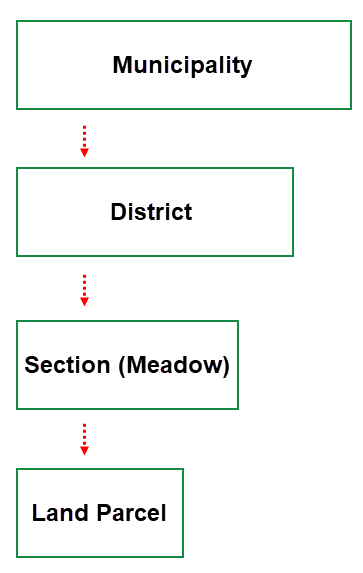
German Land Registry System Outline
This documentation refers to features associated with the concepts in this hierarchy, but depending on your country, you may not need to use them all.
Details Page
Each land parcel in VertiGIS FM has its own details page.
Land Parcel Details Page
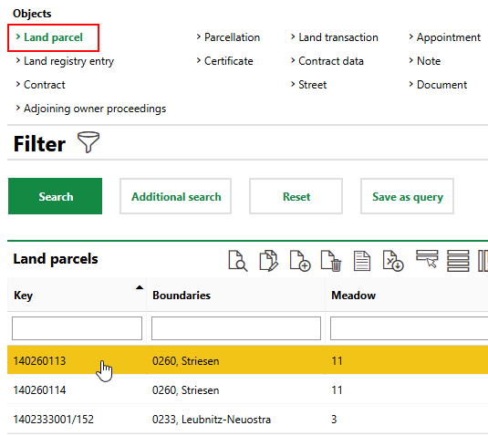
You can access a land parcel's details page either of two ways:
•on the details page for the land registry entry associated with the land parcel, in the Land Parcel section, double-click a land parcel.
•on the VertiGIS FM Parcel search page, under Objects, click Land Parcel, and then double-click a land parcel in the search grid.
Each land parcel details page is divided into the sections below.
Land Parcel
The Land Parcel section stores the land parcel's high-level properties.
Field |
Description |
|---|---|
Country |
The country in which the land parcel is located. Selectable options are stored in the Country Management administration section. |
Federal State |
The federal state (for example, province or state) in which the land parcel is located. Selectable options are stored in the Federal States section on the country's details page in the Country Management administration section. |
Municipality |
The municipality in which the land parcel is located. VertiGIS FM populates this field with the municipality in which the district selected in the Cadastral District field is located. |
Cadastral district |
The cadastral district in which the land parcel is located. |
Meadow |
In German land administration, the cadastral section or subdivision within the area selected in the Cadastral District menu. |
Location |
The land parcel's location. |
Meter |
The specific land parcel number indicated in its key, used to identify the land parcel within its meadow or section. |
Denominator |
The original land parcel number indicated after the fraction symbol in its key. This property can be used to indicate a historical link to the land parcel's original. For example, adjacent parcels that have been split may maintain the same denominator to indicate that they used to be part of the same land parcel. |
Sequence number |
In German land administration, the parcel number. |
Key |
The key for the land parcel. VertiGIS FM generates a key that is a combination of the land parcel's Federal State identifier, Cadastral District, Meadow, Meter, Denominator, and Sequence Number, delineated by a configured separator (for example, 14/0233/000003/0015152/01234). The format of the land parcel key is configured in the Land Parcel Configuration section on the details page for the land parcel's country or federal state in the Country Management administration (Administration > Master Data > Country Management). Land parcel configurations made at the land parcel's federal state level override the configuration at the country level. |
Area [m2] |
The current area of the land parcel in square meters. You cannot edit this property if there are existing change certificates associated with the land parcel. If change certificates have already been made effective for the land parcel, you can change its area by creating a boundary adjustment for the land parcel. |
Original area [m2] |
The area of the land parcel before it was split or adjusted. If the land parcel's area has been changed multiple times, this property reflects the land parcel's documented area before the most recent change certificate, and not necessarily its original area. |
Comment |
Additional comments regarding the land parcel. |
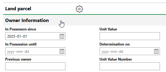
Owner Information
The Owner Information section stores information about the land parcel's current ownership. This information acts as an appendix to the owners selected in the Owner Assignment and Owner sections on the land parcel details page. To see these fields, you must expand the Owner Information section when you edit the land parcel.
Owner Information Section
Owner Information
Field |
Description |
|---|---|
In Possession since |
The date the current owner took possession of the land parcel. |
In Possession until |
The date the current owner will have possession of the land parcel. |
Previous owner |
The land parcel's previous owner. |
Subsequent owner |
The land parcel's next owner. |
Purchase price |
The price the current owner paid to acquire the land parcel. |
User |
The VertiGIS FM user associated with the land parcel's owner. You can select a person or party saved in the Contact Management module. |
Usability |
How the land parcel can be used. Selectable options are saved in the Usability catalog. |
Ground value [€/m²] |
The value of the land parcel's land per square meter. |
Land value |
The land parcel's area (saved in the Area [m2] field in the land parcel details) multiplied by the value saved in the Ground Value [€/m²] field. |
Unit Value |
|
Determination on |
The date the value of the land and unit were determined. |
Unit Value Number |
|
Expertise |
A check box that indicates that the value of the land parcel has been determined by an appraiser. |
Asset value |
The value of assets located on the land parcel (for example, buildings). |
Calculated |
A check box that, if selected, programmatically calculates the total value of assets located on this building. |
Date of expert's report |
The date the appraiser documented the value of the land parcel. |
Expertise |
The appraiser who determined the value of the land parcel. You can select a person or party saved in the Contact Management module. This field only appears if the Expertise check box is selected. |
Market value |
The market value of the land parcel. |
Urban development costs |
The costs required to prepare the land parcel for urban use. The value entered here is added to the value of the land parcel in the contract data when it is sold or acquired in a land transaction. |
Comment |
Additional comments regarding the land parcel. |
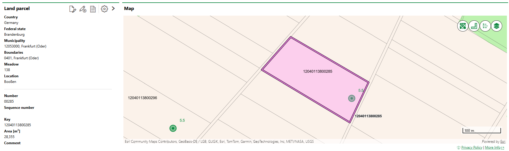
Map
If the Map section is available on the land parcel details page, the land parcel's location is shown on a web map from a VertiGIS Studio application that has been integrated with VertiGIS FM.
Land parcels are not associated with a street address and require polygons to appear on a web map. Therefore, they cannot be viewed on the Open Street Map (OSM).
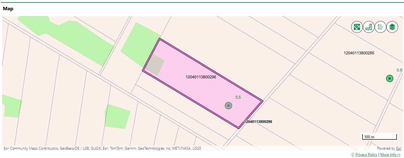
Land Parcel Shown on an Integrated VertiGIS Studio Web Map
If your organization has integrated its own VertiGIS Studio web map with VertiGIS FM and mapped a layer to land parcels, you can click the Locate (![]() ) icon on the land parcel details page to manage the GIS feature associated with the land parcel.
) icon on the land parcel details page to manage the GIS feature associated with the land parcel.
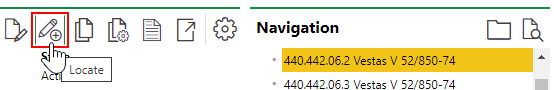
Locate Icon on the Device Details Page
Clicking the Locate button opens the Edit Object workflow. This allows you to move the location of the land parcel's corresponding feature in the GIS, unlink the land parcel and the feature so that changes to the item in the GIS are not reflected in the VertiGIS FM database (and vice-versa), or delete the GIS feature so that the land parcel only exists as an object in VertiGIS FM.
The Maps section does not appear on the land parcel details page if land parcels are not mapped to any layers in an integrated VertiGIS Studio web map and the Open Street Map (OSM) is not activated.
Land Registry Entry
The Land Registry Entry section lists the land registry entries associated with the land parcel.
Click the Additional Editing (![]() ) icon to add land registry entries to the land parcel, or to remove them. Alternatively, you can add or remove land parcels from a land registry entry on the land registry entry's details page.
) icon to add land registry entries to the land parcel, or to remove them. Alternatively, you can add or remove land parcels from a land registry entry on the land registry entry's details page.
Owner Assignment
The Owner Assignment section lists the owners of the land parcel who are associated with a VertiGIS FM contact stored in the Contact Management module. You can assign
Refer to Assign Owners to a Land Parcel for more information.
Owner
The Owner section lists the owners of the land parcel who do not have a contact entry stored in the Contact Management module.
Refer to Assign Owners to a Land Parcel for more information.
Real Estate
The Real Estate section lists the real estates located on the land parcel. Real estates are managed in VertiGIS FM Buildings.
Click the Additional Editing (![]() ) icon and then the Add (
) icon and then the Add (![]() ) icon to select a real estate from the database. Enter the percentage of the land parcel that the real estate occupies in the Share [%] text box.
) icon to select a real estate from the database. Enter the percentage of the land parcel that the real estate occupies in the Share [%] text box.
Building
The Building section lists the buildings located on the land parcel. Buildings are managed in VertiGIS FM Buildings.
Click the Additional Editing (![]() ) icon and then the Add (
) icon and then the Add (![]() ) icon to select a building from the database.
) icon to select a building from the database.
Land Transaction
The Land Transaction section lists the land transactions in which the land parcel has been sold or acquired. Ongoing land transactions involving the land parcel are also listed here.
Refer to Land Transactions for more information.
Parcelizations
The Parcelizations section lists the parcelized sections within the land parcel.
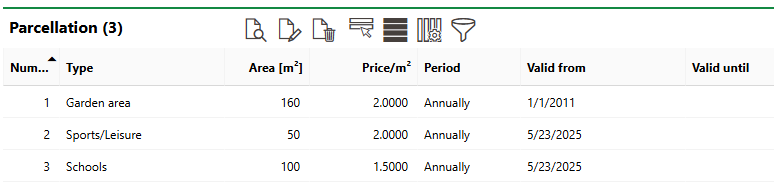
Parcelizations Section
Refer to Parcelize Sections for information about how to parcelize sections of a land parcel.
Certificates
The Certificates section lists any certificates (deeds) associated with land transactions in which the land parcel was sold or acquired.
Usage
The Usage section lists the land parcel's various uses and how much of its area is associated with each use.
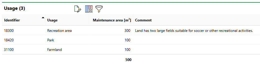
Usage Section
Usage areas differ from parcelizations in that they summarize areas of the land parcel associated with a specific use. Parcelizations refer to an enclosed area within a land parcel. For example, a land parcel could contain four different areas, each of 50 m2, that can be used for gardening. These could be entered as a single usage entry for gardening with 200 m2 as the associated area.
Refer to Specify Parcel Uses for information on how to add usages.
Valuation
The Valuation section lists the land parcel's uses, as outlined in the Usage section. In this section, you can select land value per square meter associated with the use, or enter a rate manually.
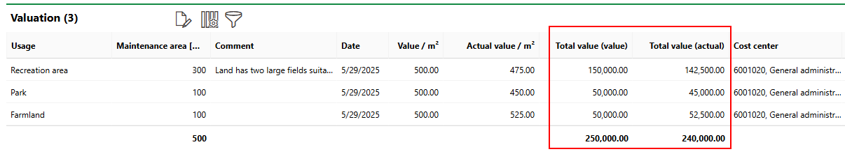
Valuation Section
Refer to Calculate Valuations for more information and instructions.
Liens
The Liens section lists mortgages taken out on parcels associated with the land parcel.
Refer to Document Liens for more information.
Contracts
The Contracts section lists the contracts associated with the land parcel. These can include standard contracts, insurance contracts, or rental agreements. You can create and manage land parcel contracts as standard contracts.
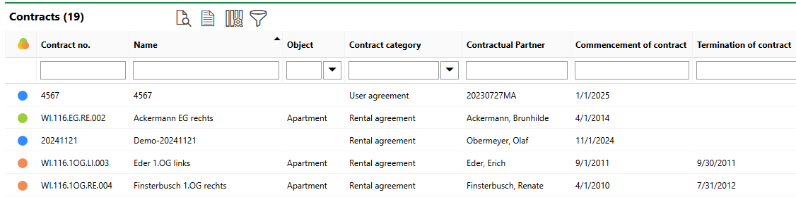
Contracts Section
You can add a Land Parcel entry to the Contract Type catalog and apply it to land parcel contracts you create.
Contracts are managed in VertiGIS FM Contracts. Refer to the VertiGIS FM Contracts product's documentation for more information.
Flexible Objects
The Flexible Objects section lists the custom data fields and forms created for this land parcel. Refer to Flexible Objects.
Checklists
The Checklists section lists checklists applied to the land parcel. A checklist applied to a land parcel can be completed once and is not associated with an order. Refer to Checklists.
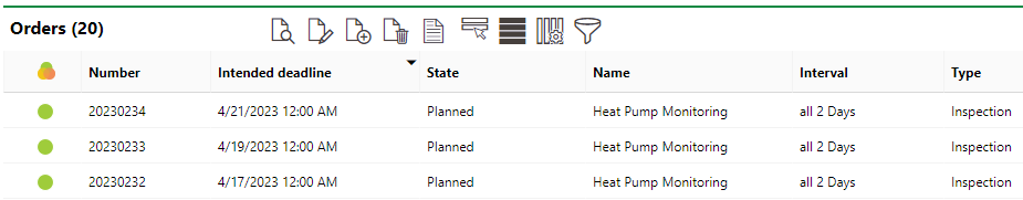
Orders
The Orders section lists scheduled orders for the land parcel. For land parcels, you can manually create orders by clicking the Add (![]() ) icon.
) icon.
Orders Section on the Device Details Page
If you create an individual order for the land parcel, its location will be used to show the location of the order on any web maps you have integrated with VertiGIS FM.
Refer to Orders for more information.
Tickets
The Tickets section lists any service desk tickets associated with the land parcel.