A land transaction is a type of contract that outlines the sale or acquisition of one or more land parcels. A single land transaction can involve multiple land parcels that are located in the same district.
Details Page
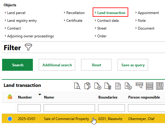
Each land transaction in VertiGIS FM Parcel has its own details page. You can access a land transaction's details page either of two ways:
•on the VertiGIS FM Parcel search page, by clicking Land Transaction under Objects and then double-clicking the land transaction whose details page you want to open.
•on the details page for any of the land parcels involved in the transaction, by double-clicking the land transaction in the Land Transactions section.
Each land transaction's details page is divided into the following sections.
Land Transaction
The Land Transaction section stores the land transaction's core details.
Field |
Description |
|---|---|
Number |
A unique number or code to identify the land transaction by. |
Name |
A name for the land transaction. |
Registry No. |
The government-assigned registry number for the land transaction, if applicable. |
Cadastral district |
The district in which the land parcel(s) involved in the transaction are located. By default, the district selected during the Create Land Transaction workflow is selected here, but you can change the selected district. |
Budget |
The internal budget to spend on land parcel acquisitions in this land transaction. |
Cost center |
The cost center associated with the land transaction. |
Account |
The ledger account associated with the land transaction. |
State |
The current state of the land transaction (Planned, In progress, Not realised, In progress). |
State |
The reason the land transaction is in the state selected in the State menu above. Selectable options are stored in the State catalog. |
Date of recording |
The date the land transaction was opened. |
Person responsible |
The employee responsible for the land transaction. Selectable options are stored in the Contact Management module. By default, the employee associated with the user signed in to the application is selected. |
Contract from the point of view of |
You can select any type of contact stored in the Contact Management module. |
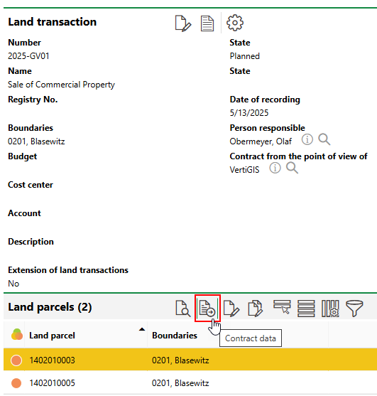
The Contact Data, Precontract, Measurement, Change Certificates, and Participants sections store data associated with the sale of a single land parcel. If the land transaction only involves one land parcel, these sections appear directly on the land transaction's details page. If the land transaction involves multiple land parcels, you must select a land parcel in the Land Parcels section and click the Contract Data (![]() ) icon to see the sections containing data relevant to the individual land parcel.
) icon to see the sections containing data relevant to the individual land parcel.
Contract Data Link to Land Transactions Involving Multiple Land Parcels
Land Parcels
The Land Parcels section lists the land parcels involved in the transaction.
Land Parcels Section
Double-click a land parcel to navigate to its details page.
Contract Data
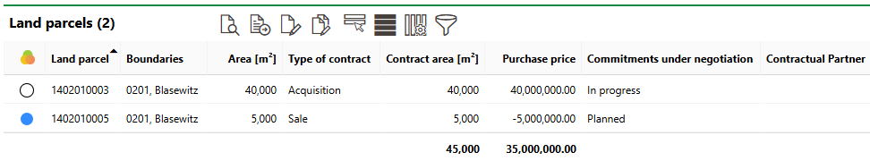
The Type of Contract column indicates whether the land parcel is being sold or acquired by the party selected in the Contract from the point of view of field in the land transaction details.
Land parcels whose Type of Contract is Acquisition have a positive value in the Purchase Price column (i.e., the party selected in the Contract from the point of view of field is spending money to acquire the parcel). Parcels whose Type of Contract is Sale have a negative value (the party selected in the Contract from the point of view of field is earning money by selling the parcel).
Each land parcel involved in the land transaction has a status, represented by a symbol that indicates the progress of the sale or acquisition of the parcel.
Land Parcel Transaction Statuses
Symbol |
Status |
Description |
|---|---|---|
|
In progress |
Details of the contract are being finalized, but it has not yet been agreed to by both parties. |
|
Planned |
The contract has been created but has not yet been signed by both parties. |
|
Not realised |
The contract has been created but is not valid. This contract status is typically assigned if a party backs out of a contract. |
|
Completed |
The terms of the sale or acquisition of the land parcel have been finalized. |


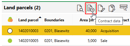
The Type of Contract, Contract Area, Purchase Price, and Commitments Under Negotiation properties are all managed in the land parcel's contract data. If the land transaction involves only one land parcel, you can edit its contract data by clicking the Edit (![]() ) icon in the Contract Data section on the land transaction's details page. If the land transaction involves multiple land parcels, select a land parcel and click the Contract Data (
) icon in the Contract Data section on the land transaction's details page. If the land transaction involves multiple land parcels, select a land parcel and click the Contract Data (![]() ) icon to edit its contract data on the individual land parcel's own contract data page.
) icon to edit its contract data on the individual land parcel's own contract data page.
Contract Data Icon
Add or Remove Parcels
You can add land parcels to the land transaction or remove them by clicking the Additional Editing (![]() ) icon.
) icon.
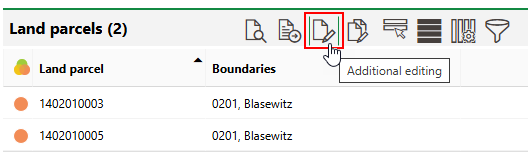
Add or Remove Land Parcels (1/2)
To add a land parcel to the transaction, click the Add (![]() ) icon and select from the land parcels located within the specified district. To remove a land parcel from the transaction, click the Delete (
) icon and select from the land parcels located within the specified district. To remove a land parcel from the transaction, click the Delete (![]() ) icon next to the parcel you want to remove.
) icon next to the parcel you want to remove.
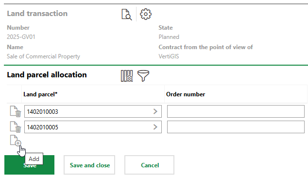
Add or Remove Land Parcels (2/2)
Contract Data
The Contract Data section stores information related to the sale or acquisition of individual land parcels involved in the land transaction. This includes the value of the parcel, the type of sale, and precontract information. You must edit this data for each land parcel involved in the land transaction before the land transaction can be marked complete. Refer to Edit Contract Data for more information.
If the land transaction only involves one land parcel, this section appears directly on the land transaction's details page. If the land transaction involves multiple land transactions, you must select a land parcel in the Land Parcels section and click the Contract Data (![]() ) icon to see the contract data relevant to the land transaction.
) icon to see the contract data relevant to the land transaction.
Precontract
You can enter information about precontracts associated with the land transaction before you edit the land transaction.
If the land transaction only involves one land parcel, this section appears directly on the land transaction's details page. If the land transaction involves multiple land transactions, you must select a land parcel in the Land Parcels section and click the Contract Data (![]() ) icon to see the contract data relevant to the land transaction.
) icon to see the contract data relevant to the land transaction.
Measurement
The Measurement section stores a check box used to indicate whether surveying is required to complete the transaction of the land parcel.
To edit the data in this section, click the Edit (![]() ) icon in the Contract Data section.
) icon in the Contract Data section.
If the land transaction only involves one land parcel, this section appears directly on the land transaction's details page. If the land transaction involves multiple land transactions, you must select a land parcel in the Land Parcels section and click the Contract Data (![]() ) icon to see the contract data relevant to the land transaction.
) icon to see the contract data relevant to the land transaction.
Change Certificates
The Change Certificates section lists change certificates associated with the land parcel involved in the land transaction.
If the land transaction only involves one land parcel, this section appears directly on the land transaction's details page. If the land transaction involves multiple land transactions, you must select a land parcel in the Land Parcels section and click the Contract Data (![]() ) icon to see the contract data relevant to the land transaction.
) icon to see the contract data relevant to the land transaction.
Participants
Refer to Participants on the Edit Contract Data topic for information about how to add participants to a land transaction.
If the land transaction only involves one land parcel, this section appears directly on the land transaction's details page. If the land transaction involves multiple land transactions, you must select a land parcel in the Land Parcels section and click the Contract Data (![]() ) icon to see the contract data relevant to the land transaction.
) icon to see the contract data relevant to the land transaction.
Contractual Partner
The Contractual Partners section lists the contractual partners involved in the sale or acquisition of the land parcels being sold or acquired as part of the land transaction. Each land parcel involved in a land transaction must have a contractual partner assigned in order for you to finalize the land transaction.
Contractual partners for a land transaction are specified when you add participants to the land transaction. Refer to Add Participants for detailed instructions.
Participants added to a land transaction do not necessarily have to be contractual partners.
Certificates
The Certificates section lists the deeds associated with the land transaction. These are documents that outline the transfer of property (in this case, land) from one party to another.
Refer to Add Deeds for information about how to add certificates to a land transaction and the data captured within them.
Appointments
The Appointments section lists the scheduled appointments (a call or in-person meeting) that are associated with the land transaction. Appointments are action items that can be scheduled for any object in VertiGIS FM. They are not the same thing as orders.
To add an appointment for the land transaction, click the Add (![]() ) icon in the Appointments section on the details page.
) icon in the Appointments section on the details page.
Notes
The Notes section lists notes that have been posted in relation to the land transaction.
Documents
The Documents section lists the documents, including image files, associated with the land transaction. Refer to Document Management for more information, including instructions on how to upload a document.