Creating versions in a geodatabase allows you parallel and secured processing of that same database by different users at the same time. This means that no data has to be locked or duplicated. Each version has a dedicated owner, ensuring clear responsibility and edit tracking. This setup supports long transactions by allowing editors to work independently in their own version over extended periods. After editing, the versions are compared with the parent version (default version) and written back to it.
You must have data from at least one versioned services to use this feature, If you do not have a versioned service, a No version management services available message is displayed at the bottom of your browser page.
You can find an overview of versioning on the Esri homepage.
To create a new version:
1.Go to Edit > Versions.
The Versions panel opens and a list of saved versions is shown.
The following tools are available in the opened panel:
Button |
Description |
|---|---|
|
Display available versioned feature services within a map to choose from. The drop-down menu is only available when more than one versioned feature service is present on the map. All listed feature services must be registered as versioned in order for them to appear in the drop-down menu. You can perform various edit operations (including save, discard, undo and redo) on multiple data sources. |
|
Full text search by versions. |
|
Display either your own versions (default setting) or the versions of all users. |
|
Show all versions or the last five used. |
|
The list of versions can be filtered by •All •Private •Protected •Public |
|
Refresh to retrieve the version from the server again. |
|
Sort versions alphabetically. |
|
Additional information such as owner, creation date, time can be shown or hidden. |
|
Close the current version and switch back to the default version. |
|
Create a new version based on the default version. |


The filter functions can be combined with each other. Their mode of operation behaves additively.
You can navigate between the versions displayed in the list using the arrow keys.
A selected version can be opened with the ENTER key.
2.Create a new version by clicking on the Create button.
The create version window appears as follows:
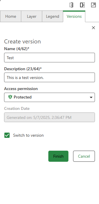
3.Fill in the required parameters, the access permissions can be described as follows:
Button |
Description |
|---|---|
|
Public: This version can be opened, edited and published by anyone. |
|
Protected: This version can be opened by anyone. |
|
Private: This version can be opened only by the owner. |
Click Finish to create the new version.
Your newly created version is switched to and displayed at the bottom of the page, highlighted with a green bar.
If no version is selected, the Default version is displayed.
Users with administrator privileges can perform all actions on any version.
The creation date of the version is assigned automatically.
You can switch to this editing version for immediate editing by ticking the "Switch to version" check-box when creating. In addition, you can switch between versions by clicking on a version in the list or via the action menu of the version.
4.Create or edit feature(s) in an edit version, then click on Save changes in quick access to save your edits.
Your changes are not automatically saved. To manually save them, click Save changes in the quick access toolbar.
The editing options of the versions depend on the access permissions.
To manage your open editing session, use the Save or Discard buttons in the Quick Access toolbar to either save or discard all changes made in the session.
5.Save your edits by either reconciling or posting changes.
In the Networks Editor, conflicts are always resolved in favor of the editing version. In case of ambiguity, a more differentiated conflict resolution must be performed via ArcGIS Pro.
Reconciliation can be skipped if you intend to Post changes directly.
6.Delete the version after it is no longer needed.
Release Lock
The Networks Editor automatically locks a version when it is opened by a specific user session. This ensures that only one user can edit a given version at a time, preventing conflicts and maintaining data integrity. To manually release the lock, use the Release Lock option from the action menu.
Releasing the lock will discard any unsaved edits made during the current session.
Version Management for Multiple Feature Services
The Networks Editor enables users to manage and switch database versions across multiple versioned feature services within a map.
All available data sources are displayed in the version manager in the order they appear in on the map.
The first service in the version manager list is selected by default, you can manually change the active service using this drop-down list.
Functions of the action menu
The following helpful functions are available via the action menu next to the displayed version:


Markups and Notes are not connected to a geodatabase version.
For a space-saving view, the compact view can be selected in the "Status bar" section.