applyEditsRequest
The applyEditsRequest allows you to configure and edit features and tables within a feature service from the Esri geodatabase. This tool can modify any feature on any layer. The VertiGIS Integrator utilizes the applyEditsRequest to handle all incoming requests by generating a feature request, enabling the ArcGIS Server's feature service to process all features from the request in a single transaction.
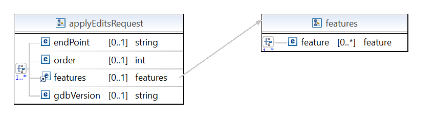
The applyEditsRequest has a collection of table rows defined in the request.
Attributes:
•The endPoint is the name of the database outbound endpoint configured in the Service endpoints from the VertiGIS Integrator (e.g. UtilityNetwork).
•The priority of requests takes place based on a specified order.
•The features are the elements that contain the actual data to be inserted or updated. The feature component includes the attribute table.
•The gdbVersion is the version to be updated by VertiGIS Integrator out of all your existing Esri versions.
Features attribute
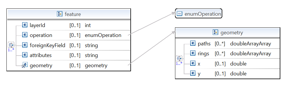
For the feature attribute you can specify the following:
•layerID: Specifies the feature service layer ID.
•operation: There are 3 types of operations available: insert, update and delete. You can insert a new feature or a table entry, update a feature or delete a feature part of the feature services (a feature layer or a feature from a table in the geodatabase).
•foreignKeyField: The foreignKeyField is not mandatory. However, if it exists, it will be used to search for features inside layers and tables. The VertiGIS Integrator will look in the tables and feature layers and will write the data where it belongs. For example, for an update, if the feature is in the layer, it will update both the feature and the layer. Each layer can have a corresponding task table, which is similar to the layer but does not yet have geometry. Thus, you could update the feature or some attributes in this table. Once you specify the geometry, it becomes the layer, and you can only update it in the feature layer. The foreignKeyField allows you to specify the primary key to search the task table and the layer table. If you have a foreignKeyField and do an insert operation, the algorithm will check if the geometry is specified in the feature, and if there is no geometry specified, the data is added to the table. Otherwise, the data is added to the layer.
•attributes: This is a collection of keys and values representing the field names and their corresponding values in the feature layer or table, which should be updated or inserted.
•geometry: You must add the geometry to a feature to be further used by the operation or foreignKeyField. Check out the 3 geometry types (point, poly line and polygon) in the XSL Inbound Template topic.
For the feature attribute, you must decide if you want to use either operation or foreignKeyField. For operation, you must define if it's an insert, an update or a delete. If you set the foreignKeyField instead, the VertiGIS Integrator will decide the operation to be used.